UrbanEye
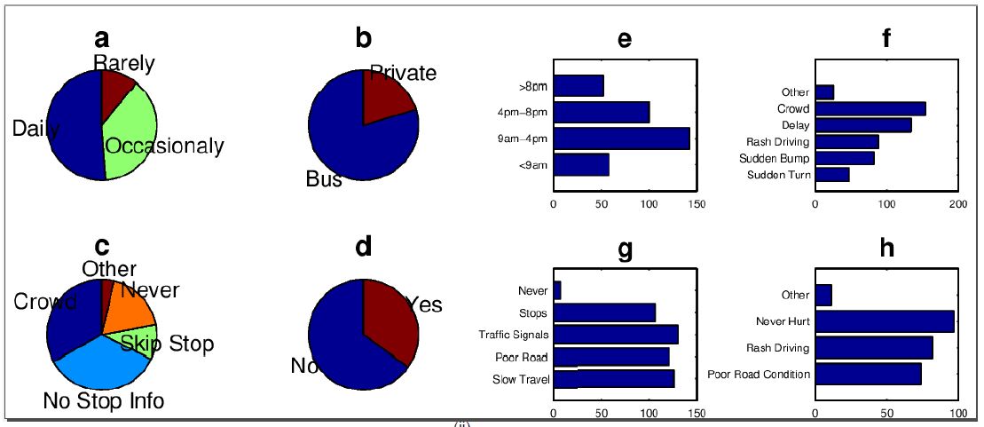
Our on-line study and on-road experiments uncover many interesting observations that motivate us to design a navigation cum alert system for the common good and specifically for the elders and disabled people. The online survey was taken by 250 people and contained 11 different questions from which we wanted to understand what are the exact problems people face during commuting. We performed the on-road experiments for a period of 6 months. The experiments were conducted at three different cities of India, namely Kolkata, Durgapur and Kharagpur . Out of these three cities, Kolkata is a Tier-I (metro) city, Durgapur is a Tier-II city and Kharagpur is a Tier-III city. The three cities span for an area of 205km2, 154km2 and 127km2 , with a population density of 24429/km2, 3700/km2 and 2312/km2, respectively according to the latest census. The experiment were conducted on all days of the week, in different time zones and in different traffic conditions. The whole day was divided into 4 time-zones of 6 hours each. Some trails were taken as early as 4:30 am and some as late as 9:30 pm (That being the last city bus plying time).
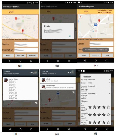
The system provides the following features:
- Alerts a commuter about an upcoming speed-breaker/turn along with a severity score
- Alerts a commuter about the stretch of upcoming bad road or a congested junction
- Informs a commuter about her exact location
- Informs a commuter about the upcoming bus stop along with ETA (Expected Time of Arrival), the average waiting time of a bus at that stop and the possibility level of skipping that bus stop
From extensive experiments, the system showed pretty high alert prediction accuracy with an average localization error of only 50m and a mean ETA error of 2.5 minutes.
Landmark Detection Strategies
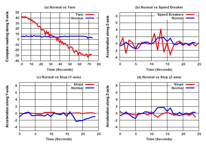
We observe that the smart-phone sensors, like accelerometer, gyroscope and compass show significant deviation from their regular values indicating a turn or speed breaker. Based on the smart-phone sensor readings, we can classify and store landmark information specific to turns, speed breakers. It is important to note that such a landmark information can also be used for route navigation, without explicitly using the GPS service; this makes the solution power efficient.
Application Screenshots